Possibly. Each regional faction has us own agenda, but they are all controlled at a higher level.
EVERY country forced their own populations to take the jab at the same time, and this indicates there's a unified superstructure above the top levels of each government.
They want us to think the governments are in control. The grand illusion.
How can there be flooding up in mountains, literally the Himalayas. The seems like one of those fake news stories that test our intelligence. Kinda like covid. They wanna say a glacier collapsed? Cuz of global warming? That wouldn't cause a flood. Just an avalanche of snow and ice. Not enough to flood.
That's an excellent question, and the answer is somewhat counter-intuitive.
Mountains trap large volumes of water in accumulated snow and ice. Similarly, many glaciers literally feed "downstream" rivers, etc.
The water has to go somewhere, right? The higher elevation mountains store significant larger quantities of potential energy, which is released as kinetic energy by gradual glacier melting, and released in massive quantities during rockslides; and the resulting vibrations even be measured across the planet with seismographs; as earthquake scale releases of energy.
That Himalayan mountains are a relatively young range, and have the tallest peaks and are concentrated in a large region, rather than an extended range like the Rockies to the Andes that form Continental dividers.
So, the Himalayas are analogous to a super-extended plateau that's covered with tallest mountain peaks, and youngest and steepest mountain valleys. Also, I think Indian subcontinental plate is still traveling inward towards Asia, so they're still growing. But I could be mistaken.
Himalayan rockslides can carry boulders for many miles along steeper valleys, and a muddy river valley amounts to rockslide lubricant. So a landslide can accumulate water and mud into a mudslide, or flood is enough water is available.
IIRC the 4 largest rivers in Asia which flow into China and India, and one is of such significance that India is actually named after the Indus river. The Indus valley is probably an older cradle of civilization, but it's separated from the middle east by mountain ranges (plural), so mesopotamia got the credit. Similarly, Chinese civilizations date back similarly. Each developed in quasi-isolation septated by the most dangerous of mountain ranges.
The massive rivers originating in the Himalayas are the source of life in each respective watershed, so control of these rivers amounts to control of the hundreds of millions of people who depend upon these rivers.
China invaded Tibet and continues to occupy it for this very reason, and it's also the source of conflict between China and India.
Nepal is a buffer state in between the two. It's the Ukraine of the India-China border.
I strongly suspect we're witnessing the prep activity for WW3.
They were saying the water was 300 ft high? Did a glacier melt? That wouldn't be enough water. Not even all the glaciers on earth melting would make sea waters rise by more than a couple feet. I'm looking at this from a side of science, not worried about WW3 or anything like that. Not cuz of a fake flood anyway.
It was not water. It was a slurry mix of everything in its path. The friction would melt whatever ice was in it. It was not 300 feet high, but it did reach that level at points along the way - like a bobsled going up the side of a turn.
WW3 is not off the table, and it wouldn't surprise me if this was man-triggered, but I'm skeptical until I learn more about the region and issues.
 Log in

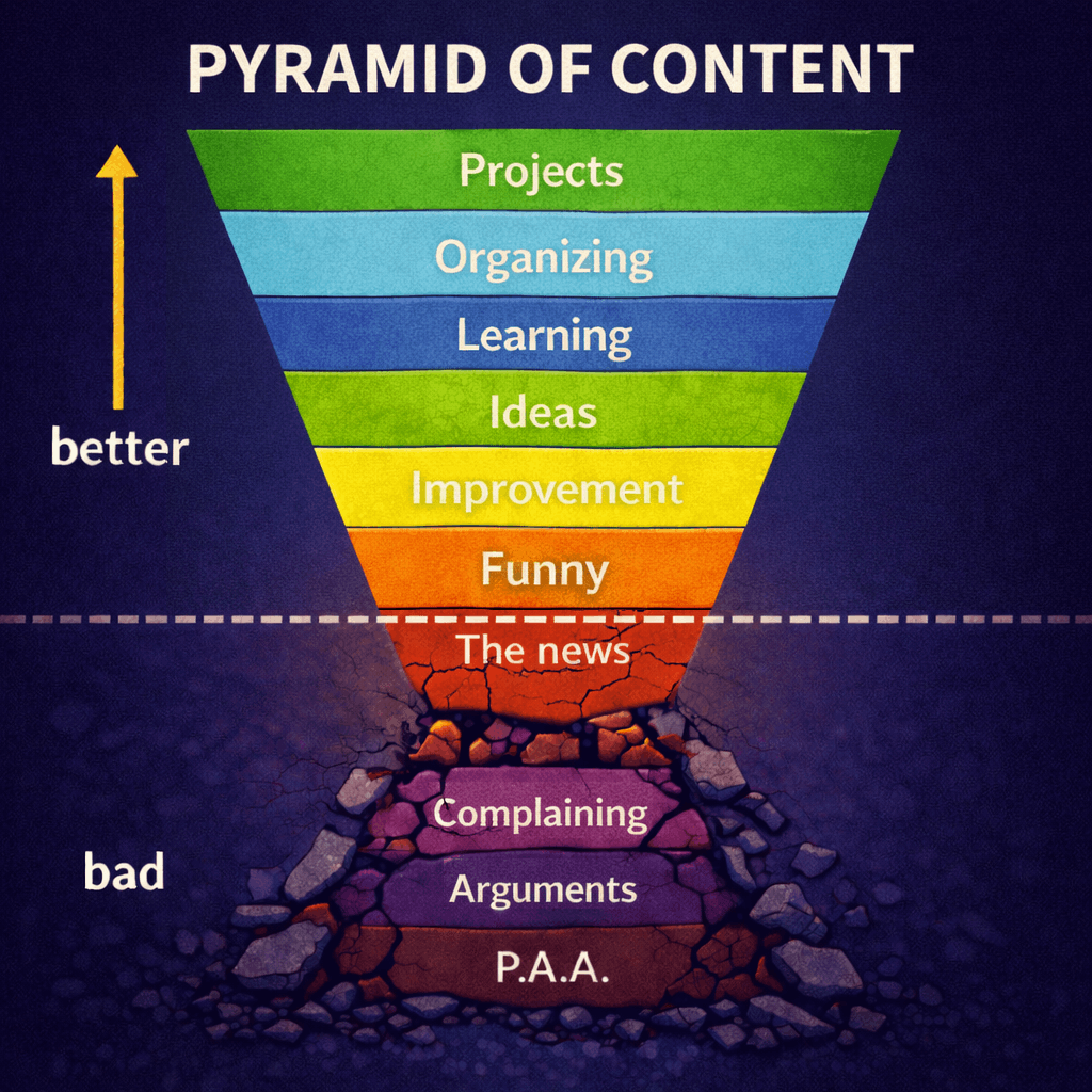



I may stand corrected, as Chinese tunneling may have caused the initial collapse.
I knew it was the Chinese; their hatred of religion and their attempt to take over Nepal are legendary.
Your regurgitation of propaganda has been noted but it is not legendary.
Possibly. Each regional faction has us own agenda, but they are all controlled at a higher level.
EVERY country forced their own populations to take the jab at the same time, and this indicates there's a unified superstructure above the top levels of each government.
They want us to think the governments are in control. The grand illusion.
Further, just because the "leadership" claims to be against each other doesn't mean the people are (besides those fooled by tribalist propaganda).
How can I xpost this to IncludesA4BreastedWomanAndChakwitRecommendIt
"Very mountainous regions."
Only if chakrit recommend it
How can there be flooding up in mountains, literally the Himalayas. The seems like one of those fake news stories that test our intelligence. Kinda like covid. They wanna say a glacier collapsed? Cuz of global warming? That wouldn't cause a flood. Just an avalanche of snow and ice. Not enough to flood.
That's an excellent question, and the answer is somewhat counter-intuitive.
Mountains trap large volumes of water in accumulated snow and ice. Similarly, many glaciers literally feed "downstream" rivers, etc.
The water has to go somewhere, right? The higher elevation mountains store significant larger quantities of potential energy, which is released as kinetic energy by gradual glacier melting, and released in massive quantities during rockslides; and the resulting vibrations even be measured across the planet with seismographs; as earthquake scale releases of energy.
That Himalayan mountains are a relatively young range, and have the tallest peaks and are concentrated in a large region, rather than an extended range like the Rockies to the Andes that form Continental dividers.
So, the Himalayas are analogous to a super-extended plateau that's covered with tallest mountain peaks, and youngest and steepest mountain valleys. Also, I think Indian subcontinental plate is still traveling inward towards Asia, so they're still growing. But I could be mistaken.
Himalayan rockslides can carry boulders for many miles along steeper valleys, and a muddy river valley amounts to rockslide lubricant. So a landslide can accumulate water and mud into a mudslide, or flood is enough water is available.
IIRC the 4 largest rivers in Asia which flow into China and India, and one is of such significance that India is actually named after the Indus river. The Indus valley is probably an older cradle of civilization, but it's separated from the middle east by mountain ranges (plural), so mesopotamia got the credit. Similarly, Chinese civilizations date back similarly. Each developed in quasi-isolation septated by the most dangerous of mountain ranges.
The massive rivers originating in the Himalayas are the source of life in each respective watershed, so control of these rivers amounts to control of the hundreds of millions of people who depend upon these rivers.
China invaded Tibet and continues to occupy it for this very reason, and it's also the source of conflict between China and India.
Nepal is a buffer state in between the two. It's the Ukraine of the India-China border.
I strongly suspect we're witnessing the prep activity for WW3.
They were saying the water was 300 ft high? Did a glacier melt? That wouldn't be enough water. Not even all the glaciers on earth melting would make sea waters rise by more than a couple feet. I'm looking at this from a side of science, not worried about WW3 or anything like that. Not cuz of a fake flood anyway.
It was not water. It was a slurry mix of everything in its path. The friction would melt whatever ice was in it. It was not 300 feet high, but it did reach that level at points along the way - like a bobsled going up the side of a turn.
WW3 is not off the table, and it wouldn't surprise me if this was man-triggered, but I'm skeptical until I learn more about the region and issues.